Autumn Has Arrived. So Has The Sewage!

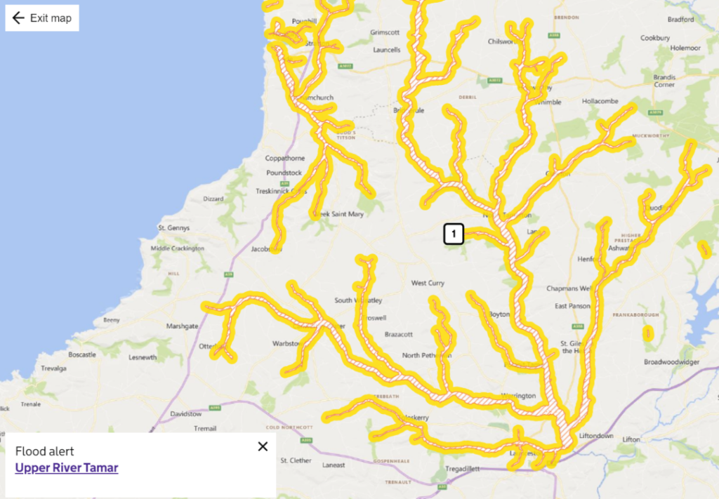
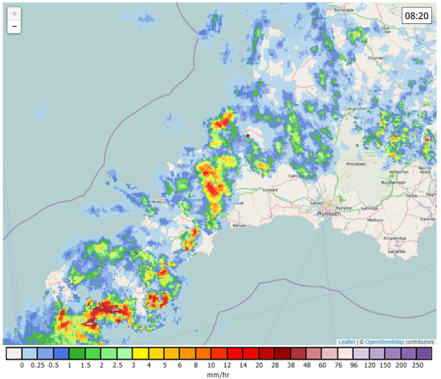
Following a very pleasant period of dry weather earlier in September the rains have arrived in North Cornwall.

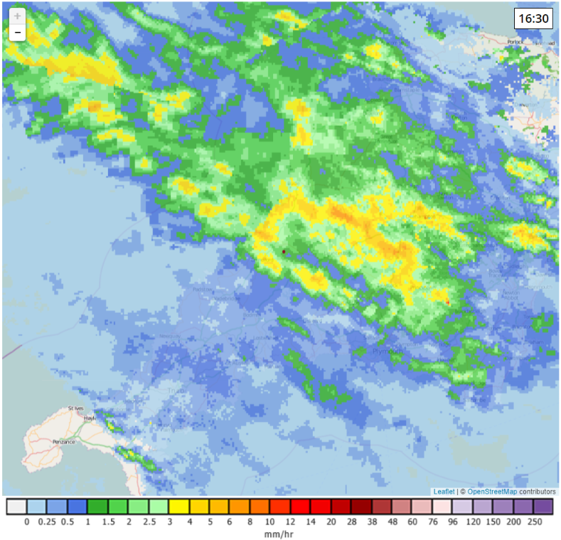
Here is the Netweather.tv rain radar map from yesterday evening:

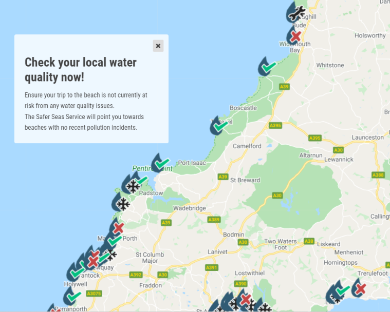
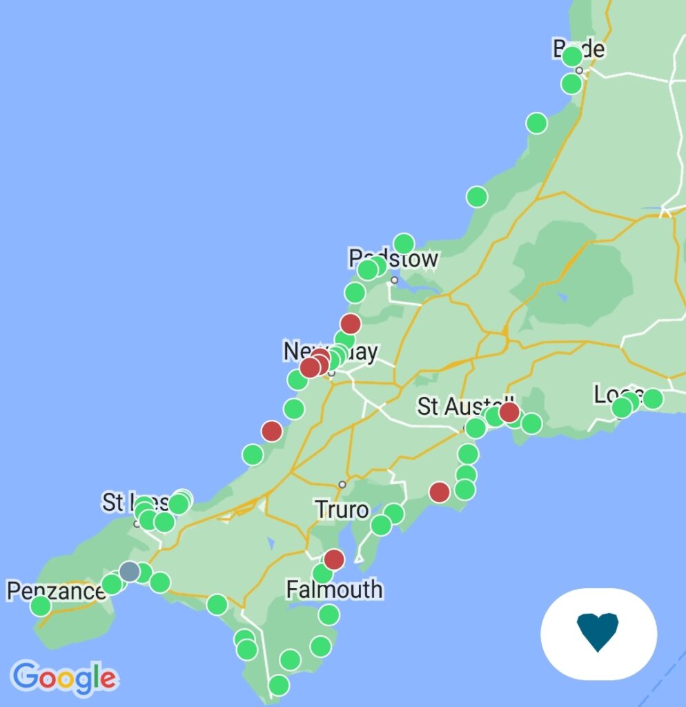
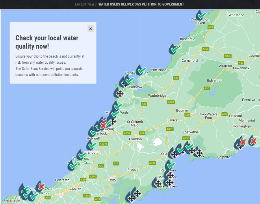
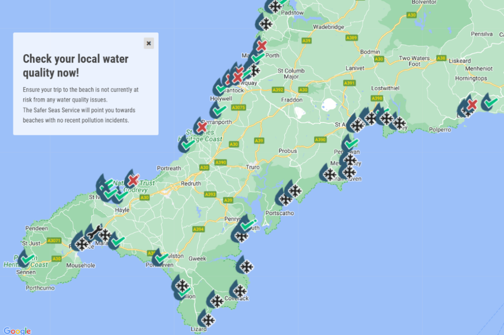
I suggested on Twitter that it would be prudent to consult the Surfer’s Against Sewage water quality map this morning. This is what it reveals:


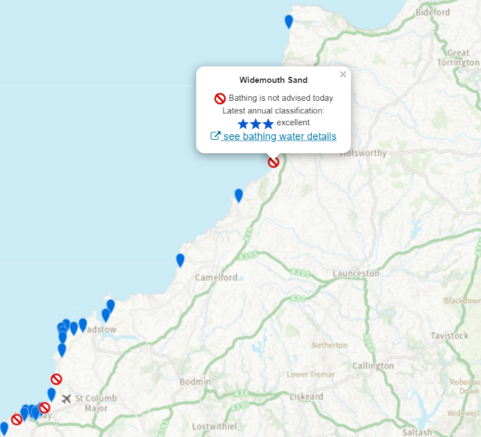
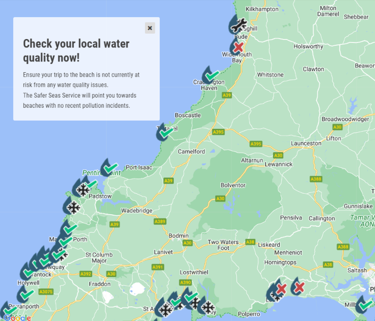
Although not yet shown on the SAS map the Environment Agency’s bathing water quality map suggests not going surfing today at our local big beach break:

In related news here is this morning’s graph of the pound/dollar exchange rate:

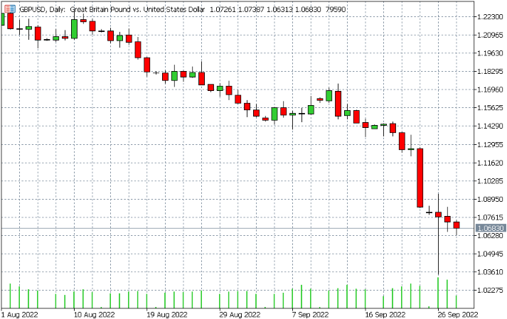
It seems everything is going down the pan simultaneously here in Kernow, under the current Government in Westminster. Except bankers’ bonuses in the City of London of course! According to the Guardian:

The City watchdog is being urged to investigate whether leaks of Kwasi Kwarteng’s mini-budget allowed billionaire hedge fund investors to make “small fortunes” by betting against the pound.

Tulip Siddiq, the shadow economic secretary to the Treasury, said the Financial Conduct Authority needed to determine whether it was possible for traders to have used insider information to benefit from the crashing currency.

The pound fell to an all-time low of $1.03 against the dollar overnight on Monday before recovering lost ground amid speculation that the Bank of England would raise interest rates to shore up the economy.

Perhaps we need our own currency here in Kernow? Bring back the dynar!

[Edit – October 3rd]

This news comes from the south coast of Cornwall, but according to their Facebook page the Gyllyngvase Surf Life Saving Club’s Endless Summer Swim event on Sunday was postponed for a week:

Unfortunately due to the deluge of rain yesterday, we have a sewage alert on the beach and with another wave of wet weather due for the morning, we have decided to postpone until next Sunday This year has felt like we’ve had constant alerts on the beach so please South West Water can you take responsibility and do something about it?

[Edit – October 22nd]

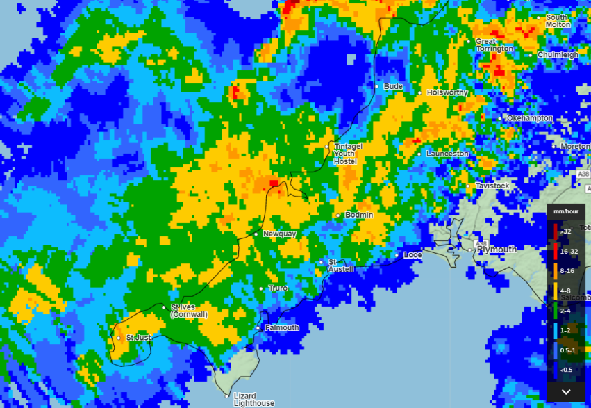
There’s been a fair bit of rain in these parts recently. Here’s the NetWeather.tv rain radar from yesterday morning for example:

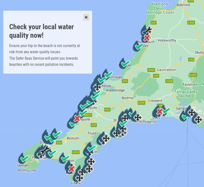
Hence it doesn’t come as a big surprise that this morning several beaches on the North coast of Cornwall are yet again suffering sewage pollution according to the Surfers Against Sewage water quality map:

[Edit – October 28th]

After an all too brief respite from sewage pollution incidents along the coast of North Cornwall, this morning there has been a discharge at Widemouth Sand, our local big beach break:

There have also been incidents at Seaton and Millandreath on the south coast. Further south still, at Long Rock “sewer systems in this location are under maintenance and the water company has temporarily disabled real-time alerts”

[Edit – October 30th]

Widemouth Sand is clear again on the Surfers Against Sewage water quality map. However further west there are now several sewage pollution incidents along the north coast of Cornwall:

Some graphic videos of the pollution incident at St. Agnes have been posted on Twitter:

[Edit – November 1st]

After a very brief respite Widemouth Bay has suffered another sewage pollution incident:

So has St. Agnes:

[Edit – November 3rd]

There has been plenty of rain across Cornwall this week. Here’s the Met Office’s rain radar map at 4 PM yesterday:

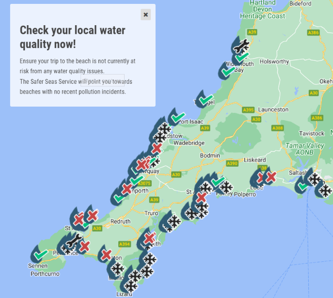
Consequently there are now numerous sewage pollution incidents all round the coast:

The only good news locally is that Widemouth Bay is currently not red flagged, but at Summerleaze beach in Bude South West Water “has [still] temporarily disabled real-time alerts.”

Watch this space!

Another North Cornwall Flood Alert

According to the United Kingdom Government’s “Check for Flooding” service, which is currently being beta tested:

Flood alert for Upper River Tamar

Flooding is possible – be prepared

This Flood Alert remains in force. Flooding is possible this afternoon and overnight into Thursday 30th December. Last night’s rain has caused river levels to rise and we expect these to remain high throughout the rest of today and into tomorrow morning. This may result in flooding to low lying land and roads close to rivers this afternoon and overnight into Thursday morning 30th December. However, flooding to properties is not currently expected. Take care near the areas of concern and monitor your local weather conditions. We are monitoring river levels and have staff in the area checking for and clearing blockages. This message will be updated on Thursday morning or earlier if the situation changes.

Flood alert area: Bude, Helebridge, Bridgerule, Canworthy Water, Launceston and Yeolmbridge

As is often the case at such times, the Surfers Against Sewage pollution map reveals metaphorical “red flags” at Widemouth Bay, Mawgan Porth and Fistral Beach in Newquay:


The Omicron Variant in Cornwall

Confirmed Covid-19 cases across Cornwall have been slowly decreasing recently, but that is about to change. Here is the current national case rate graph:

Here too is some recent news from London:

Of course we don’t have many towns here in North Cornwall, but a few miles up the A39 from Davidstow the (5 days delayed) rolling weekly case rate in the Bude MSOA has just crept above 800 again:

[Edit – December 29th]

After a break in reporting over the Christmas holiday the UK Government is issuing Covid-19 data again. There has been a big jump in UK wide cases today, no doubt partly due to some catching up after Xmas:

Continue reading “The Omicron Variant in Cornwall”

The Covid-19 Holiday Season in Cornwall

The school summer holiday season is drawing to a close, and August Bank Holiday is almost upon us. Matt Hancock was one of many hundreds of thousands to travel down here from up country earlier this month:

The effect on Covid-19 cases here in North Cornwall is all too evident. The Camelford and Davidstow area is now in the top category for cases:

However we are still a long way behind Newquay East, which today broke the 2,000 cases per 100,000 people per week barrier:

Here once again is the “heat map” showing the age distribution of cases across Cornwall as a whole for the current wave of Covid-19:

The upper limit on the 7 day “rolling rate” legend really requires updating. In the 15-19 age group the rate has now reached 5,080.6. For 20-24 year olds it is 2,419.4.

The Post G7 Covid-19 Outbreak in Cornwall

We commented yesterday on the current outbreak of Covid-19 cases further west in Cornwall than Davidstow, and suggested that the cause may be the recent G7 Summit in St. Ives, which finished on Sunday.

Here is yesterday’s map:

Together with a “heatmap” showing the age distribution of cases across Cornwall as a whole:

The far right of the image suggests that during this so called “third wave” of Covid-19 cases, the 15 to 24 age range has been the hardest hit. Possibly that’s because this section of the population has yet to be vaccinated?

The official data for June 10th have also just been released, and this is how the latest map looks:

Truro, Redruth and Mevagissey are no longer pure white, as they were on June 9th. A total of 27 cases in St. Ives doesn’t sound like a lot, but it’s an enormous percentage increase on the previous 7 days.

Watch this space!

The 2021 G7 Summit in Cornwall

The forthcoming summit of the G7 nations is taking place on the north coast of Cornwall, just down the road from Davidstow . According to the G7 UK web site:

In June, Prime Minister Boris Johnson will welcome fellow G7 leaders to one of the most beautiful parts of the UK: Carbis Bay in Cornwall.

Other parts of the region will also play a key role in the Summit, including neighbouring St Ives, Falmouth and Newquay airport.

With over 400 miles of coastline, Cornwall’s stunning landscape provides a perfect setting for world leaders to come together and discuss how to respond to global challenges like coronavirus and climate change.

Here’s one of my recent pictures of some of that coastline, including part of Cornwall’s industrial heritage and some large waves!

Cornwall Council has recently issued guidance about the G7 summit, which is likely to be of interest to both residents and visitors to the area over the next couple of weeks. Here it is:

https://www.cornwall.gov.uk/council-news/g7-cornwall-2021/

Here too are the maps detailing the forthcoming restrictions on your movements around St. Ives, Newquay Airport and Falmouth during the summit:

Here too is an image from a recent article in The Guardian:

Devon and Cornwall force expect challenges ranging from foreign leaders’ security to gull attacks on drones.

The police force in charge of law and order at the G7 summit in Cornwall has said it faces challenges ranging from the “tricky” business of liaising with foreign leaders’ security details to not wrecking people’s holidays – and stopping gulls from attacking their drones.

Devon and Cornwall police, which is leading the operation for next month’s summit, said officers, backed by military planners and intelligence agencies, would patrol from the land, air and sea to keep the event safe.

On Tuesday it allowed reporters to watch firearms officers going through their paces and drone pilots practising their skills as final preparations were made for the largest operation in its history.

Officers fired Heckler and Koch G36 carbines and Glock pistols in an indoor range at the force’s headquarters in Exeter. They will also have access to a range of other equipment including baton rounds, typically used in riot control, Taser stun guns, smoke and stun grenades and incapacitant spray.

It probably makes sense to stay away from those areas over the long weekend of the G7 event, unless you have a particular reason to go there? Surfing Watergate Bay certainly looks to be fraught with difficulty!

Surfing Lusty Glaze in a February Heat Wave!

The images below are from beyond the parish of Davidstow, but Lusty Glaze beach just this side of Newquay is an easy drive from here for any visitors staying in the Davidstow area:

Apart from the rather bare beach that may look like the end of August but actually the pictures were taken on February 27th 2019, towards the end of the “heat wave” that produced the warmest English February temperatures since the United Kingdom’s Met Office records began:

However the water temperatures in the Atlantic Ocean just off the coast of North Cornwall are currently nowhere near those that will be achieved by the end of August! Hence my neoprene hood to keep the dreaded “surfer’s ear” at bay!

This was the Magic Seaweed north coast surf forecast for last Wednesday: