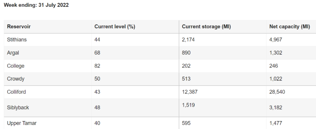
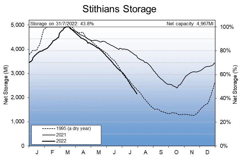
As the weeks have passed the answer to that question seems increasingly likely to be “Yes”. Hence we’ll begin August 2022 with the current water levels of Cornish reservoirs provided by the South West Lakes Trust:
As you can see the water levels in both Colliford and Stithians reservoirs are already below their lowest levels last year. Colliford is also well below its level at the beginning of August 1995, a particularly dry year for Cornwall and other parts of the United Kingdom.
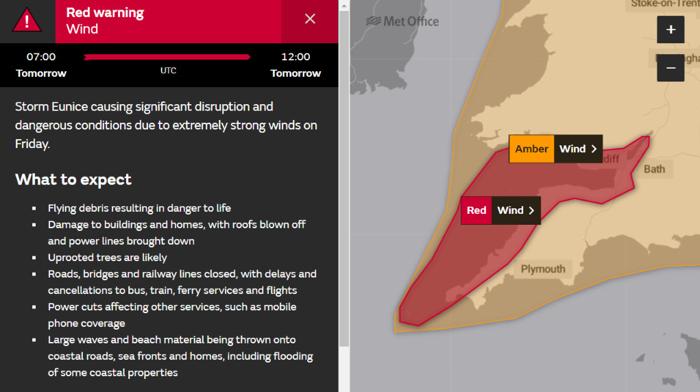
The Met Office have just issued a rare red wind warning for the North Cornwall coast when Storm Eunice arrives tomorrow morning:
. The storm looks fairly innocuous on the current Met Office synoptic charts:
However Storm Eunice is a “bomb cyclone“, so hurricane force winds are certainly possible in the Davidstow area. The forecast for tomorrow may still change, but the Met Office currently put it this way:
Extremely strong west to southwesterly winds will develop over southwest England and south Wales early on Friday. Widespread inland gusts of 70-80 mph are likely and up to around 90 mph near some coasts, with dangerous conditions on beaches and seafronts. Winds are expected to ease from the west during the late morning.
What to expect
Flying debris resulting in danger to life
Damage to buildings and homes, with roofs blown off and power lines brought down
Uprooted trees are likely
Roads, bridges and railway lines closed, with delays and cancellations to bus, train, ferry services and flights
Power cuts affecting other services, such as mobile phone coverage
Large waves and beach material being thrown onto coastal roads, sea fronts and homes, including flooding of some coastal properties
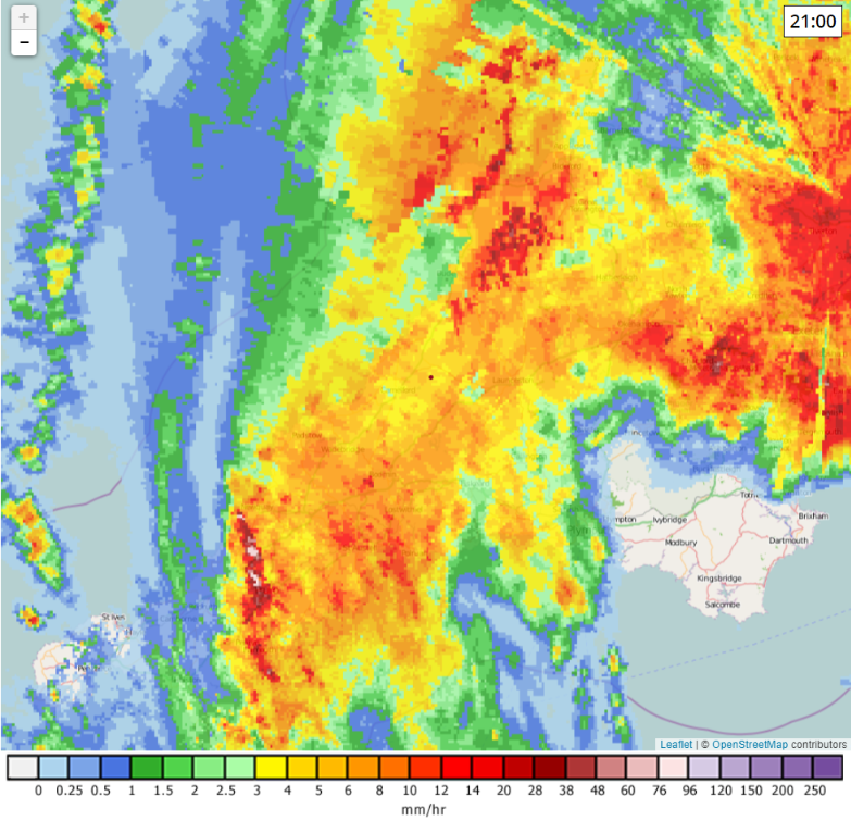
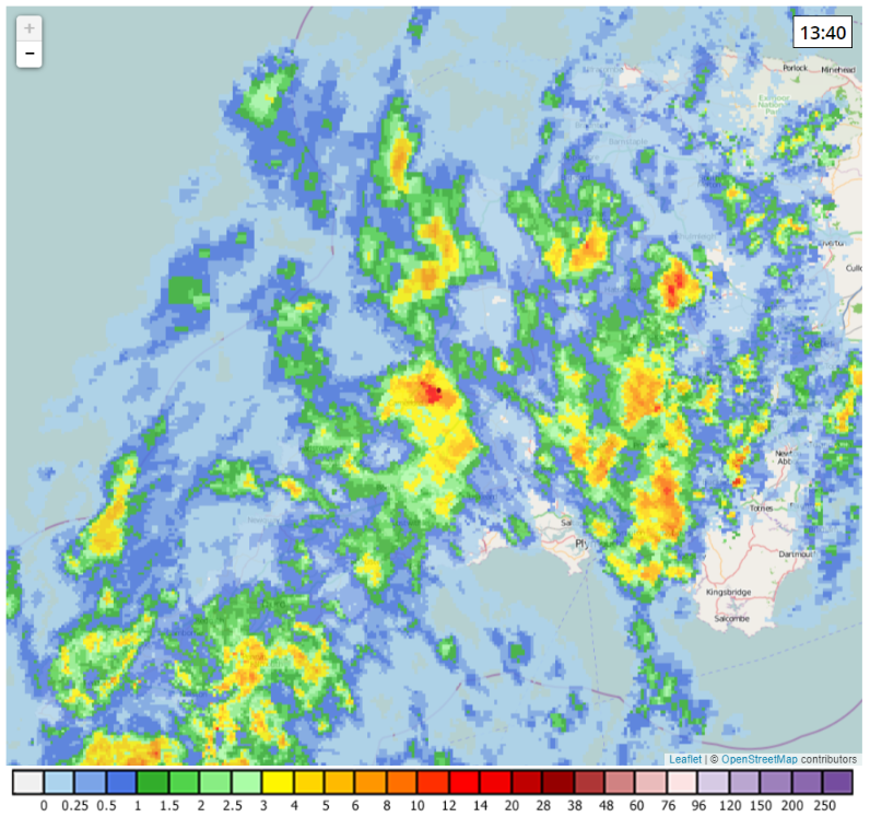
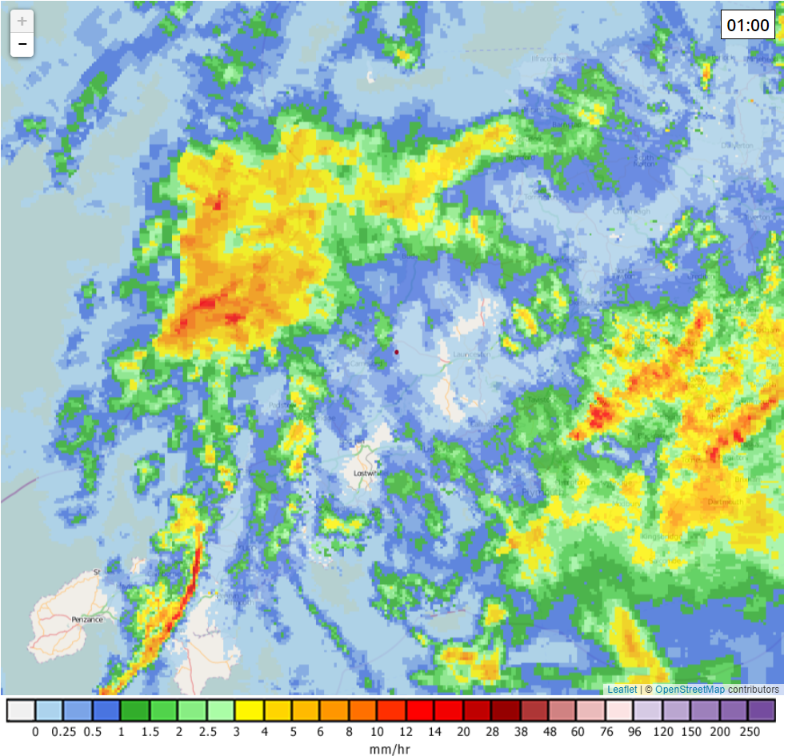
Another downpour last night has resulted in all too familiar news this morning. Here’s the NetWeather.TV rain radar view of Cornwall at 9 PM last night:
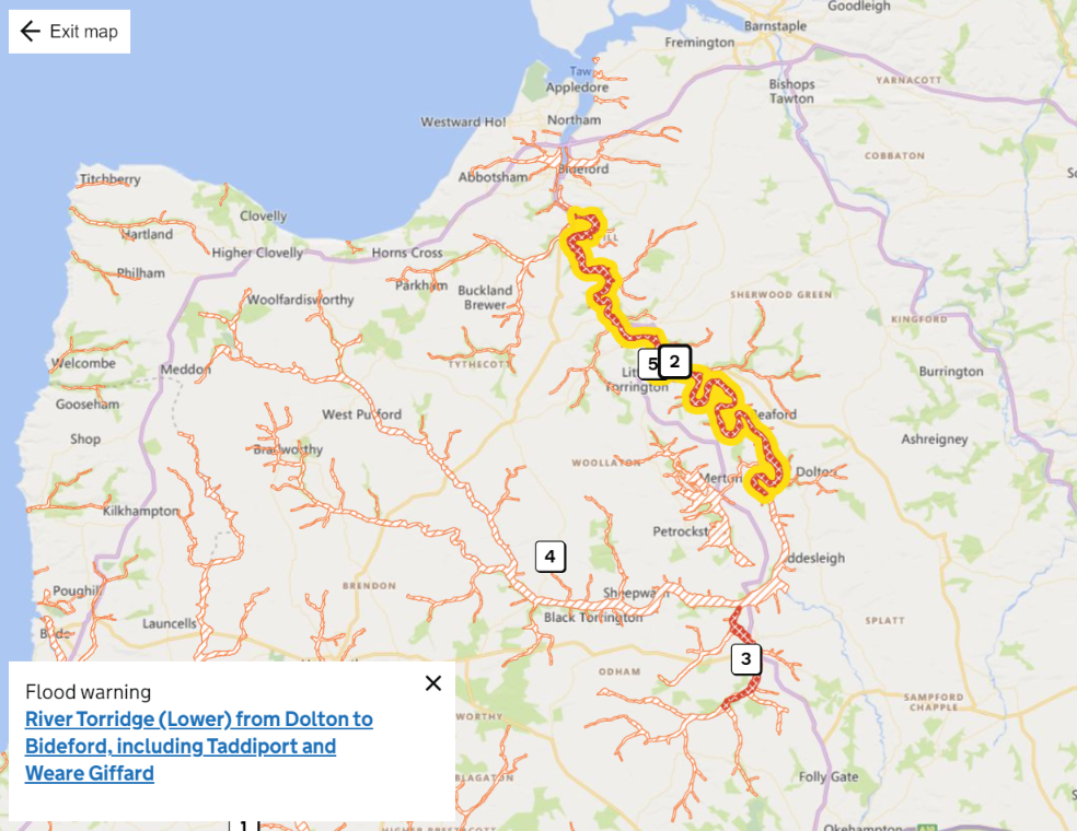
Davidstow is under all that rain dropping cloud somewhere! This morning there are flood warnings in place for North Devon, and flood alerts across North Cornwall:
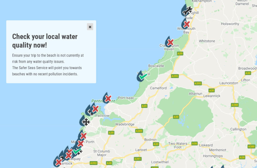
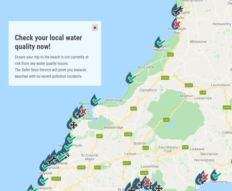
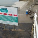
What’s more the Surfers Against Sewage map reveals that nearly all the beaches in North Cornwall also have water quality warnings in place:
The little low tide “beach” at Trebarwith Strand is currently clear, but Watergate Bay is not.
[Edit – October 26th]
Here is Baroness Jones from the Green Party explaining the problem on BBC Newsnight:
"We've known about this for nearly 30 years and yet water companies still insist on paying out billions to shareholders and have not invested in the infrastructure to deal with this."
This seems to be the meat of the letter I received from Scott Mann MP a couple of days ago:
The facts are that we have a combined sewer system in this country, meaning rainwater and sewage both flow into it. This means that heavy rain and storms can lead to additional pressure on the system that needs to be released”. lt is not a coincidence that discharges happen most often during or after a storm. lf this pressure is not discharged the wastewater – including sewage – will back up into the streets and into people’s homes. This is not hyperbolic; it is a fact. The age of this Victorian sewerage system means that the complete elimination of storm overflows would be extremely challenging. Unfortunately, they have always been a part of our wastewater infrastructure and until now little action has been taken by any government or party.
One of the recent amendments in the Lords would have required work to be done to eliminate sewage discharges, and I was one of several hundred MPs who opposed it. Initial estimates of the work necessary to achieve this are in the region of £150 billion and upwards. To put that in perspective, this is more than the entire budget of the NHS. These costs would inevitably be passed onto taxpayers or water bill payers. No sensible legislator could have backed this. I am of the view that the water companies should foot the bill for improvements over time and not the taxpayer, so these improvements must be manageable.
That rather begs the question about where we would be now if the necessary improvements had been started a decade or two ago? And indeed what the actual cost would be in today’s day and age!
[Edit – November 1st]
This tweet from Professor Dieter Helm seems apposite at this juncture?
“The sad reality of 30 years of privatisation has been high gearing, high profits and dividends, and investment well below what could have been achieved.” https://t.co/yhGkI3B4fU
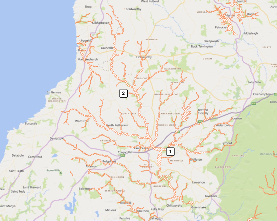
After almost continuous heavy rain, hopefully the end is in sight for the current series of pollution incidents on the beaches of North Cornwall. Several beaches are not being monitored at this time of year, but currently Widemouth Bay and Trevone are the only ones still marked in red on the Surfers Against Sewage water quality map:
Hopefully those two will get the all clear tomorrow
[Edit – November 5th]
In answer to my question above about “the actual cost of the necessary improvements to the UK’s ageing sewage infrastructure”, the Government has just announced:
An independent research project that considers options, costs and benefits for reducing storm sewage discharges in England.
Reducing sewage discharges from storm overflows is an important priority to protect the environment.
This research, the first assessment of its kind, was commissioned by the Storm Overflows Taskforce – made up of Defra, the Environment Agency, Ofwat, CCW, Blueprint for Water and Water UK – and funded by Water UK.
The independent research, carried out by Stantec, presents a detailed overview of potential approaches that will act as an important evidence base for government action.
The Storm Overflows Taskforce will now consider the report and its recommendations to:
support the development of the best mix of policy solutions
inform the government plan on storm overflows to be published in September 2022.
The report itself evaluates the costs and benefits of a range of scenarios. The methodology used is summarised like this:
The policies tested consider the universal implementation of permits to control storm overflow spill frequency to an average of either 40, 20, 10, 5 or 0 (zero) times per year (named F40, F20, F10, F5 and F0, respectively).
Three scenarios are also considered, describing the engineering approach used to deliver policies. The first relies on a conventional approach to capture spills from storm overflows using network storage (W) which is sized sufficiently to capture spills and allow for these to slowly return to the sewer network for treatment.
The other two augment the conventional approach with partly or wholly nature-based technologies (retrofitted SuDS) at two levels: 10 percent of impermeable area controlled (S10) and 50 percent of impermeable area controlled (S50). In this context, controlled means that these flows do not enter the combined sewer system. The SuDS solutions are implemented in addition to sewer network storage; therefore creating mixed grey-green solutions. The S10 level of SuDS is at a modest level across the catchment, whilst the S50 level is at a high level. Controlling runoff from 50% of impermeable area (S50) is broadly equivalent to preventing all highway runoff entering combined sewers in a fully combined catchment.
The costs of the various approaches are summarised in the following infographic:
There seem to be a wide range of available options that cost considerably less than £150 billion, and that’s before accounting for the associated benefits.
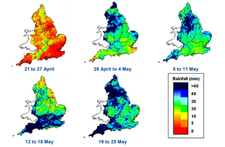
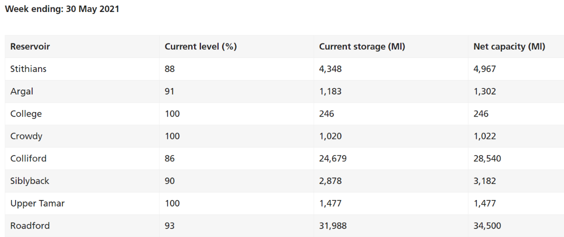
Just over a month ago we reported that North Cornwall had experienced a very dry April. Today we are compelled to report that North Cornwall has experienced a very damp May!
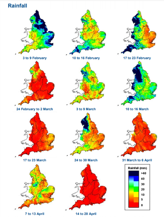
The Environment Agency publishes a weekly report on recent rainfall across England. Here’s an interesting graphic from the most recent edition:
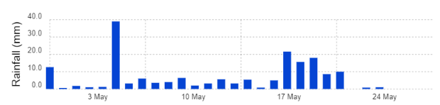
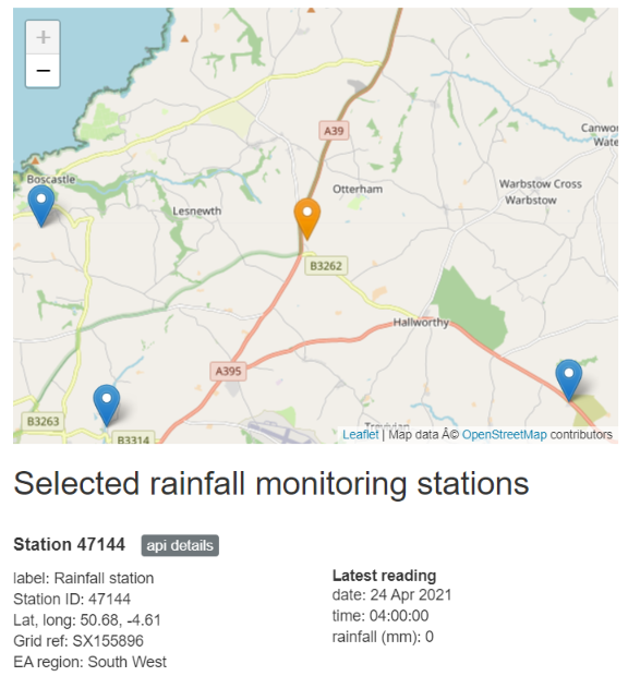
The EA also maintains a large number of automated rainfall monitoring stations across the country. As revealed by this map, the nearest one to Davidstow is up the hill near the A39 “Atlantic Highway”:
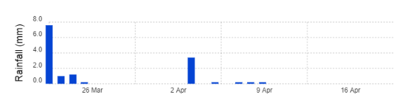
Here’s its rainfall record for the past four weeks:
The last really rainy day is just about to disappear off the end of the chart.
After a really rainy winter this perhaps makes a very pleasant change? Don’t forget to water your gardens though!
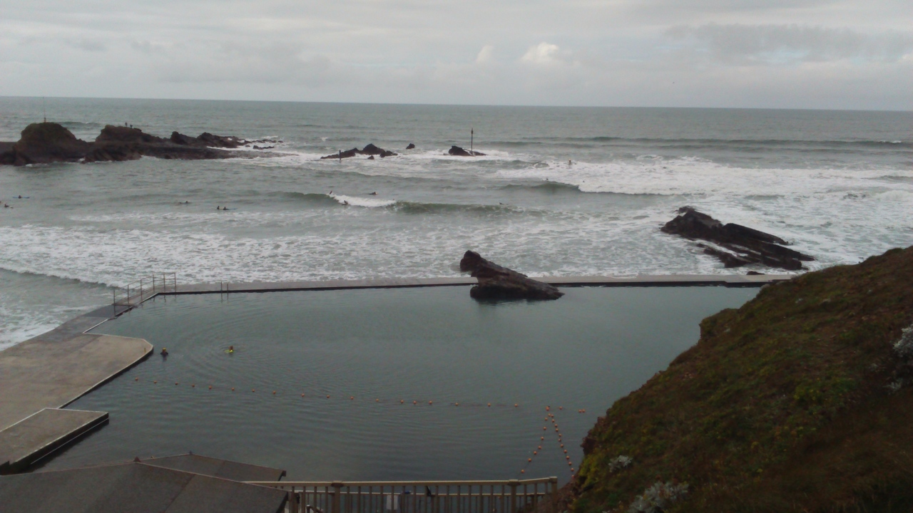
As discussed in the article describing my surfing session in Newquay earlier this year, the images below are from beyond the parish of Davidstow. However Summerleaze Beach in Bude is an even easier drive from here for any visitors staying in the Davidstow area:
Not only is there surf when the wind and North Atlantic swells permit, there is also the much calmer Bude Sea Pool (almost) all day, every day:
If you’re very lucky, as I was this weekend, you may even find yourself in the midst of an art installation on your next trip up the A39 Atlantic Highway!
If you’re actually in or near Bude and/or Davidstow this weekend more information about the Reflect Arts+Minds Project can be found at:
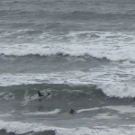
The images below are from beyond the parish of Davidstow, but Lusty Glaze beach just this side of Newquay is an easy drive from here for any visitors staying in the Davidstow area:
Apart from the rather bare beach that may look like the end of August but actually the pictures were taken on February 27th 2019, towards the end of the “heat wave” that produced the warmest English February temperatures since the United Kingdom’s Met Office records began:
However the water temperatures in the Atlantic Ocean just off the coast of North Cornwall are currently nowhere near those that will be achieved by the end of August! Hence my neoprene hood to keep the dreaded “surfer’s ear” at bay!
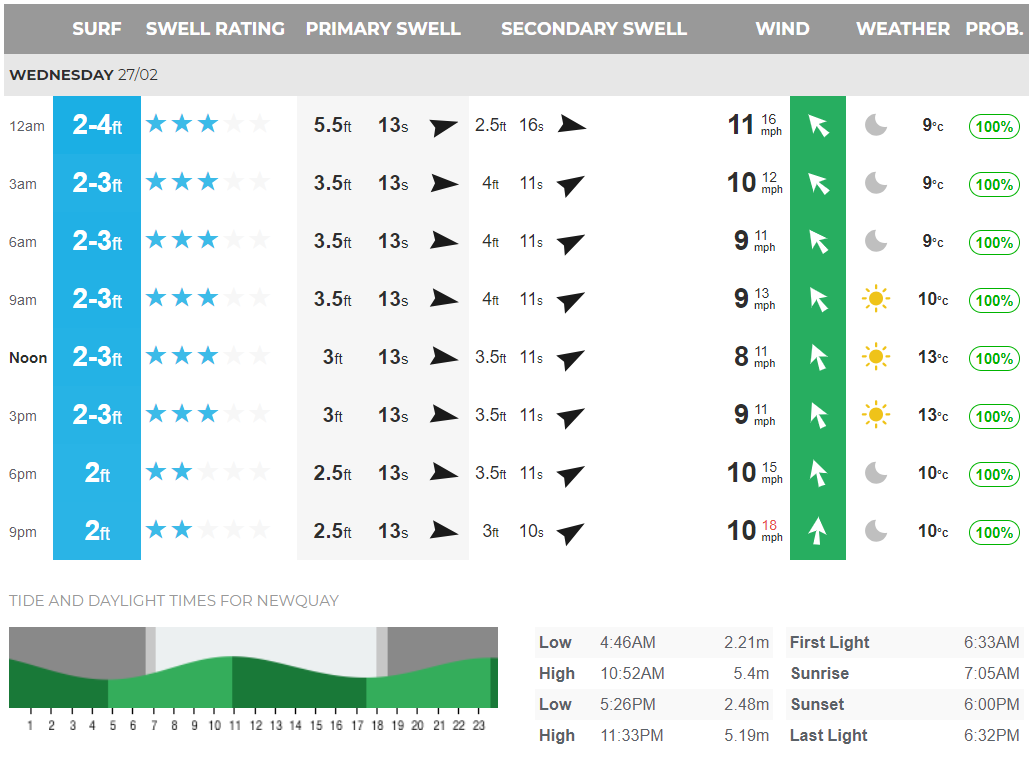
This was the Magic Seaweed north coast surf forecast for last Wednesday: